
Firefighters Continue to Gain Ground Against Montana’s Wildfires
RIVER ROAD EAST FIRE (17, 098 acres - 6 miles due East of Plains)
The fire has grown by just 15 acres over the past 24 hours, and is now 7% contained. 651 firefighters, 41 engines and 6 helicopters are assigned to the River Road East fire.
On the northeast side of the fire, line has been constructed from just west of Henry’s Peak to the Clear Creek Road. In this area just south of Henry creek, firefighters are working directly alongside the active fire edge, removing fuels between the fire and the constructed control line to prevent the fire from advancing. Firefighting personnel and heavy equipment, including skidders and feller-bunchers are working in tandem to implement a mixture of direct and indirect control line along the east side.
On the south-central side of the fire, north of the Flathead River, a finger of the fire burned down near the river. Firefighters are assessing their options for containment should that part of the fire cross the river.
Internal portions of the fire are anticipated to continue to produce smoke. The southwest side of the fire is burning in very steep, rugged, and remote terrain. Crews continued to evaluate control options that can be effective while providing for firefighter safety.
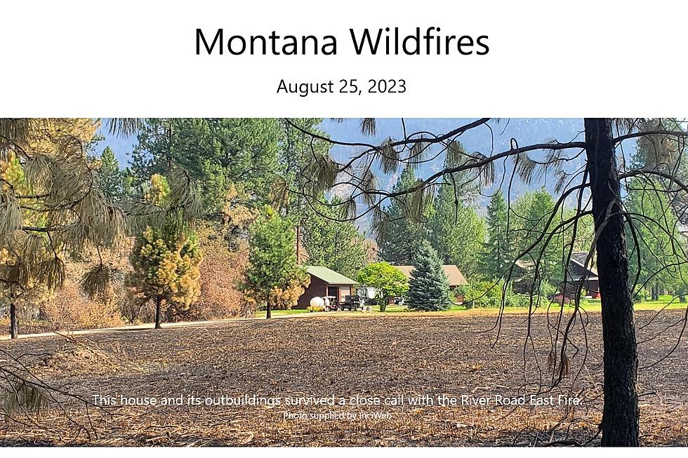
Engine crews worked in the Highway 200 corridor patrolling and mopping up around structures. (Today's cover photo shows a home that survived a close call,)
The fire will remain active as dry weather moves into the area. Expect to see smoke and increased fire behavior in unburned areas. Resources will continue combinations of direct and indirect control line construction on the north, northeast, and east sides of the fire. On the northwest side, crews will continue to strengthen the recently constructed control line. Engines will continue to patrol and secure line around the structures within the Highway 200 corridor and work towards increased containment.
Because of the progress firefighters have been making, the Sanders County Sheriff’s Office opened the McLaughlin Creek Road to residents only yesterday. The area is still under a pre-evacuation warning.
SIDNEY FIRE (198 acres - 16 miles west of Heart Butte)
Trails in the area remain closed. CLICK HERE for the Helena-Lewis & Clark National Forest's latest closure map.
RIDGE FIRE (3665 acres - 6 miles southeast of Hungry Horse)
The Hungry Horse Reservoir remains closed to all public access, including both the east and west side roads. As firefighting efforts continue on the Ridge Fire, the Tin Soldier, and other fires in the area. Visit the Flathead National Forest website for more information.
A line of showers and potential thunderstorms with gusty, erratic winds is expected to pass through the fire area later this afternoon through this evening. A warming and drying trend is predicted through the weekend. Expect to see increased activity on all incidents as weather improves. The fire has gained a few acres since the last report, and is now 76% contained.
Today crews will begin moving the mechanical logging equipment out of the area. Ground resources will also attempt to enter areas that have been inaccessible since the heavy rains earlier this week, to evaluate fire conditions. The repair group will continue evaluating restoration needs.
Southwest Area Incident Management Team 1 will host a community meeting at the Glacier Bible Camp at 5:00 PM on Sunday, August 27th.
The Flathead County Sheriff’s Office has rescinded the pre-evacuation notice from the east side of Spotted Bear Road to West Glacier. Visit the Flathead Sheriff’s office Facebook page for details
DORIS POINT FIRE (1585 acres - 8 miles south of Hungry Horse)
Crews monitored the southwest and east sides of the fire perimeter yesterday, as well as evaluated hazard trees along FS RD 895 and mitigated rolling debris around the campground. Today ground resources will continue with that mission with an emphasis on hazard tree removal projects. The fire gained about 50 acres since the last report, and is 58% contained.
TIN SOLDIER COMPLEX (8165 acres - 17 miles east of Swan Lake)
The total area covered by these fires has increased by about 500 acres since the last report, and now stands at 8165-acres, with 20% containment.
Yesterday crews put in good work containing the area of slop over along Meadow Creek and continued prep work along Meadow Creek towards Tin Creek, which included the use of mechanical thinning equipment. Today crews will further their missions from yesterday by monitoring the secured area of slop over for remaining hotspots, continue with mechanical thinning along Meadow Creek, and conduct prep work on FS RD 2628 towards FS RD 2828 near the Hyrdo Dam. Additionally, personnel engaged in point protection will maintain pump operations around structures.
An evacuation order issued by the Flathead County Sheriff for Heinrude community remains in effect. Visit the Flathead Sheriff’s office Facebook page for details.
EAST FORK FIRE (4614 acres - 12 miles south of Trego, MT )
Some communities remain in a Pre-Evacuation Warning. Residents may return to their homes under a Pre-Evacuation Warning, but may need to leave again on short notice. For more information, go to the Sheriff’s Department website.
BOWLES CREEK FIRE (6985 acres - Near Skalkaho Pass)
Fire crews remain present along Hwy 38, Skalkaho Road. Motorists traveling in the area should be aware of increased traffic and fire operations.
Containment remains at 23%. Firefighters are utilizing firing operations and fuels reduction work to strengthen lines, as well as continuing to prep areas for potential future firing operations. Additionally, firefighters are scouting contingency plans in the event fire activity increases and impacts Hwy 38.
BIG KNIFE FIRE (7275 acres - 5 miles east of Arlee)
Wisps of smoke are visible within the footprint of the fire area, as the temperatures rise, and sheltered fuels continue to dry out. A final piece of line will be constructed today, reaching from the S Canal Rd to the fire’s edge. Crews are beginning to “time out”, reaching the end of their working days here and either returning home or being reassigned to other fires. With moderated fire activity, remaining crews have been busy with the start of suppression repair work. In the last two days, almost 10 miles of hose lay from S Canal Road and Agency Creek have been backhauled and crews have been busy rolling it to send back to the cache.
In the coming weeks, dozer line will need to be naturalized and the rest of the equipment will be removed off the fire line. The objective is to leave it in as good condition, or better, than we found it.
The Big Knife Fire is currently 1.25 miles north of the Rattlesnake Wilderness Boundary (Lolo National Forest) with no significant growth towards the Lolo National Forest in the last week.
Several areas near the base of the mountains west of the Big Knife Fire remain in PRE-EVACUATION WARNING by order of the Lake County Sheriff. The Tribal Primitive Area, Belmore Slough and Burnt Cabin Roads are closed.
COLT FIRE (7154 acres - 15 miles northwest of Seeley Lake)
The Lolo National Forest has lifted the closure of the Rainy Lake Campground, Alva Lake Campground and their access roads. All other Forest closures remain in place, including Lakeside Campground. More information for closures is available HERE.
NIARANDA FIRE (20,365 acres - 12 miles west of Elmo) & MILL POCKET FIRE (1869 acres - 3 miles West of Hwy. 28)
Both the Niarada Fire and Mill Pocket Fire are 100% contained.
The Lake County Sheriff's office lifted the pre-evacuation warnings related to the Niarada Fire. All residents may bring their livestock back home.